Three types of satellite: Visible
Image

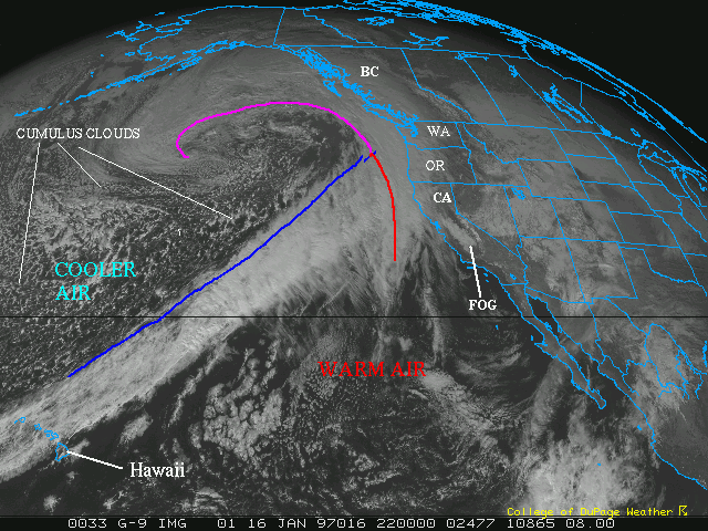
This is your typical comma head storm. The islands
in the far left corner are Hawaii. Notice how the clouds
extend from Hawaii to the Pacific Northwest (Washington and
Oregon). This marks your cold front. Southeast of this large
feature, the air is warm. Norhwest of this feature, it is
cold. The ocean waters are relatively warm compared to the
cold air mass moving over it which is why you see the numerous
amount of little white dots behind this cold front. These
white specs are cumulus clouds. The colder air moving over
the warmer ocean waters sets up an unstable airmass.
The warm front is not very well defined as is often
the case out west but if you look closely, the clouds over
Washington and Oregon as well as off the coast, are much
smoother than the clouds extending southwestward from that
area. These are stratus clouds due to the isentropic lift
ahead of the warmfront, where air is constantly rising on
a slant over the colder air below.
The clouds that extend north and also swirl back into
the center of the comma head is the occluded front. The center
of that comma head is the low pressure system. The low has
moved back into the cold air, as cold air fills into the system.
The surface low is basically directly underneath of the mid
or upper low (as opposed to it's typical cyclogenesis spot,
downwind from the upper trough. This location is normally
to the southeast of the upper low).
The clouds in the interior of California is fog.
Satellite Example Page
 The
Nexlab Home Page
 The
Nexlab Home Page
