Static Stability
(FROM "A REVIEW
OF STATIC STABILITY INDICES AND RELATED THERMODYNAMIC PARAMETERS"
RANDY A. PEPPLER, ILLINOIS STATE WATER SURVEY, 1988)
Meteorologists are concerned with static stability parameters
in order to understand convective weather patterns. If the atmosphere
is unstable with abundant low-level moisture and a mechanism exists
to lift the air (thereby releasing the potential instability),
convective weather and rainfall (showers) can develop. Conditions
favorable for these events are warm, moist air at low levels;
cool, dry air aloft; and surface convergence coupled with upper-level
divergence. A study done by Wilson and Scoggins (1976) report
that convective activities exist "in areas where the low
and middle troposphere is moist, air is potentially and convectively
unstable, and has upward motion, in combination with positive
moisture advection, at either the surface or within the boundary
layer."
Static stability is defined as the stability of the atmosphere
in hydrostatic equilibrium with respect to vertical displacements.
These displacements are explained by using the parcel method.
The parcel is a hypothetical box that does not allow any transfer
of heat into or out of the box, but allows only adiabatic temperature
changes. The stability of the parcel is dependent upon the parcel's
motion after a forced displacement from an original location.
As the parcel undergoes adiabatic change, its temperature is
compared to that of the surrounding environment so as to relate
differences in density. A parcel that returns to its original
position is considered stable while one that will continue away
from its original position is unstable. One that is displaced
and remains at its new position is considered neutral.
Since the density differences are affected by the differences
between the adiabatic lapse rates and the environmental lapse
rate, one may denote absolute instability occurring when
the environmental lapse rate,  , exceeds
the dry adiabatic lapse rate,
, exceeds
the dry adiabatic lapse rate,  ; absolute
stability occurring when
; absolute
stability occurring when  is less
than the wet adiabatic lapse rate,
is less
than the wet adiabatic lapse rate,  ;
and conditional instability when
;
and conditional instability when  falls between
  and
and  .
The atmosphere may be considered potentially unstable,
(or synonymously convectively unstable) when referring
to the atmosphere's potential for releasing instability,
even when the atmosphere appears to be stable. A layer may be
strongly stable (that is, it has a negative lapse rate) and yet
still considered to be potentially unstable. This is favored
when the bottom of a specific layer is warm and moist while the
top of the layer is substantially drier.
.
The atmosphere may be considered potentially unstable,
(or synonymously convectively unstable) when referring
to the atmosphere's potential for releasing instability,
even when the atmosphere appears to be stable. A layer may be
strongly stable (that is, it has a negative lapse rate) and yet
still considered to be potentially unstable. This is favored
when the bottom of a specific layer is warm and moist while the
top of the layer is substantially drier.
 Click for
a larger image
Click for
a larger image
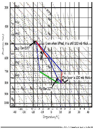
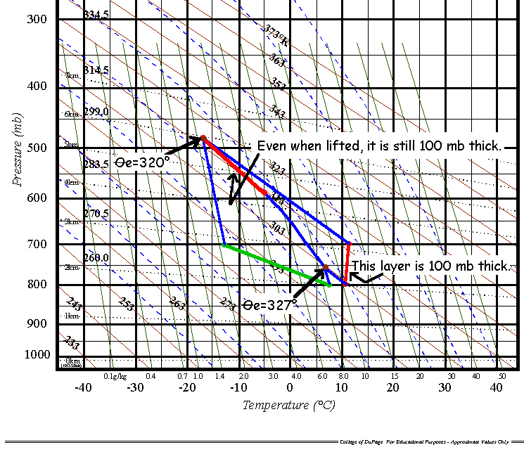
Figure
1
The layer method of determining stability involves dynamically
lifting a layer of the atmosphere by low-level convergence, an
approaching front, etc., similar to the parcel. The restriction
of horizontal mixing is eliminated. However, the vertical pressure
difference between the top and bottom of the layer must remain
constant. As the layer is lifted, the bottom of the layer will
saturate more quickly than the top, hence cooling slower than
the drier top. This lifting will result in a destabilization
of the atmosphere. (See Figure 1.) The original layer is considered
convectively unstable if at the point of total saturation, the
layer has a lapse rate greater than the  .
This criterion can be represented by determining the change of
the equivalent potential temperature with height. If
.
This criterion can be represented by determining the change of
the equivalent potential temperature with height. If  ,
the atmosphere is considered convectively unstable.
,
the atmosphere is considered convectively unstable.
Notice that the layer started out absolutely stable (a slight
inversion) As the top cooled dry adiabatically and the bottom
cooled slower, the layer destabilized. If  e at the
bottom is greater than e at the top, as it is in this
case, then the layer's lapse rate is greater than the local wet
adiabatic lapse rate and the layer is convectively unstable.
e at the
bottom is greater than e at the top, as it is in this
case, then the layer's lapse rate is greater than the local wet
adiabatic lapse rate and the layer is convectively unstable.
Back to 115notes Menu
 Click for
a larger image
Click for
a larger image