The Lemon Technique
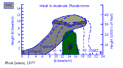
- Radar plays an important role in determining thunderstorm
severity. One can relate updraft strength with echo top height
and peak reflectivity, also noting thunderstorm trends. The Lemon
technique assumes moderate to strong vertical wind shear.

Click for a larger image
- Updraft tilt caused by increase in environmental winds. Precipitation
particles in the updraft fall out creating low, mid and upper
level echoes to be vertically aligned.
Click for a larger image
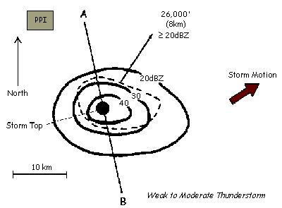
- On a PPI, there are no strong reflectivity gradients, and
no mid-level overhang. The storm top will be downstream of the
updraft with strong upper winds, but will be over the strongest
low-level echoes. The storm motion is determined by the mean
1000-500 mb wind. This is usually approximated by using the 700
mb flow as a guide.
- At this point the thunderstorm needs to be watched carefully
for signs of intensification.
Click for a larger image
Click for a larger image
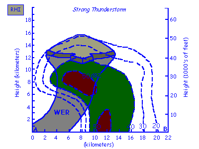
- As updraft increases in strength, it rises with less of a
slope and ascends to greater heights. The strong updraft is able
to penetrate higher without the effects of the wind shear. Precipitation
forms in the mid-levels of the storm and is carried downwind of
the updraft. The Weak Echo Region (WER) is shown on the RHI,
marked by precipitation above weak returns. The echoes above
the WER make up the mid-level echo overhang.
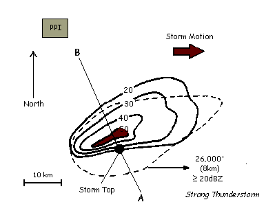
- On the PPI display, the echo elongates in the direction of
the mean winds, while the storm top shifts over the greatest precipitation
echo gradient on the right, or updraft) edge of the storm.
- In a multicell, other tops will exist. This top will now
be above a strong low level reflectivity gradient on the updraft
storm flank indicating either new cell development, or a sustained
single updraft, as in a supercell. Mid-level echo overhang sticks
out over low-level gradient by 6 to 25 km. A storm with these
characteristics moves slower and veers to the right of other non-severe
echoes (approximately 70% of the mean wind and 30° to the
right). This echo identifies a hailstorm often with large hail
(>3/4" diameter) and gusty surface winds.
- At this point there are strong indications that the storm
is severe and hence a warning is likely to be issued. The deviant
motion of the thunderstorm indicates that the storm most likely
contains a mesocyclone. Further proof of this fact can be shown
by examining Doppler products.
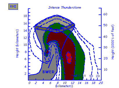
Click for a larger image
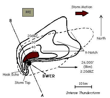
Click for a larger image
- A more intense updraft will rise almost vertically reaching
heights of near 60,000 ft. There are strong reflectivity gradients
above the Bounded Weak Echo Region (BWER) and the storm top is
over this as well. This configuration is indicative of potential
tornadic activity. A BWER indicates strong rotation about a vertical
axis. A horizontal cut through the storm will show the BWER
as a "hole" in the reflectivity.
- If there is rotation within this storm, the rear flank downdraft
will wrap around the read of the storm, carrying with it precipitation
and helping to form the radar detected "hook" echo.
- The mean flow is blocked by the updraft, so heavier precipitation
is carried around the updraft forming the V-notch.
- Precursor to the supercell storm is often a non-severe multicell.
As each new cell becomes larger than the previous, one eventually
dominates and the supercell structure results.
- A storm will not be severe unless the VIP 5 echo extends above
26,000 feet (8km), the mid-level echo is strong, and a WER exists.
- It is during the existence of the BWER and its collapse that
large hail develops and then the tornado. The tornado often signals
the end of the severe stage, the storm resuming a non-severe configuration
again. In certain conditions, the BWER can once again develop.
- A supercell that travels to the right of the mean winds is
considered to be extremely dangerous with a high potential for
tornadic development. These storms are capable of changing the
vertical wind profile, making it more favorable for increasing
the rotation within the mesocyclone. The storm relative wind
shear, or helicity, is a major concern for severe weather forecasters.
ES 115 Notes
 Radar Notes
