Conditions Necessary for the Development of Tropical Storms
Only 10% of these disturbances intensify
into a tropical depression (containing a closed circulation) and
once they intensify, only 70% will reach tropical storm status;
sustained winds 35 kts. A hurricane is a tropical storm with
sustained winds greater than 65 kts (74 mph)
Thunderstorms release large amounts of latent heat which warm
the mid- and upper-troposphere. As a result of this heating,
air begins to diverge consequently lowering the surface pressure.
Surface convergence is enhanced by friction. However, because
of the warm waters, the adiabatic cooling as the air crosses the
isobars is balanced by conductive heating. A warm core is thus
maintained, perpetuating the storm. If there were vertical shear,
the heat in the core of the hurricane would be transported away
from the area of maximum surface convergence. Friction therefore
balances the storms strength by limiting its intensity but maintaining
its fuel supply (latent heat).
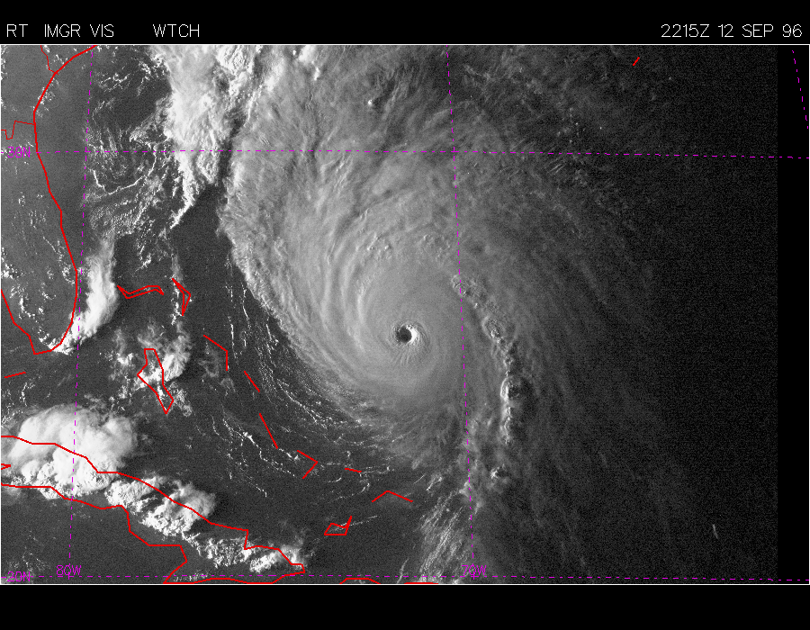
The eye of the hurricane is the "calm in the middle of the
storm" where the skies are clear and winds subside to near
calm. The eye is formed as the intensity of the storm increases.
The winds rotating around the center of the storm can no longer
make the turn due to the law of the conservation of angular momentum.
Air spins rapidly as the air crosses the isobars toward lower
pressure. However, it rises before it gets to the exact center.
The eye wall which surrounds the eye contains the most turbulent
conditions and the most intense thunderstorms. The eye remains
clear because of small amounts of subsidence to fill the void
of air at the surface.
The typical diameter of the storm is on the order of 650 km whereas
the typical eye diameter is less than 50 km. 950 mb is an expected
pressure of an average hurricane, although pressures below 900
mb have been recorded. Hurricanes are generally steered by the
upper tropospheric winds but forecasting remains difficult due
to the hurricanes affect on the large scale winds.
Spiral bands of thunderstorms spiral out from the hurricanes
center giving warning of its approach and the storm the familiar
octopus-like form.
The storm surge is the most deadly and destructive part
of a hurricane. For every 1 mb drop of atmospheric pressure,
the sea level raise 1 cm. Coupled with strong on-shore winds,
and a "sloshing" effect, the level of the sea can raise
several meters, inundating the shore with a wall of water and
several meters higher with enormous waves.